Water conveyors and waterways in Lombardy

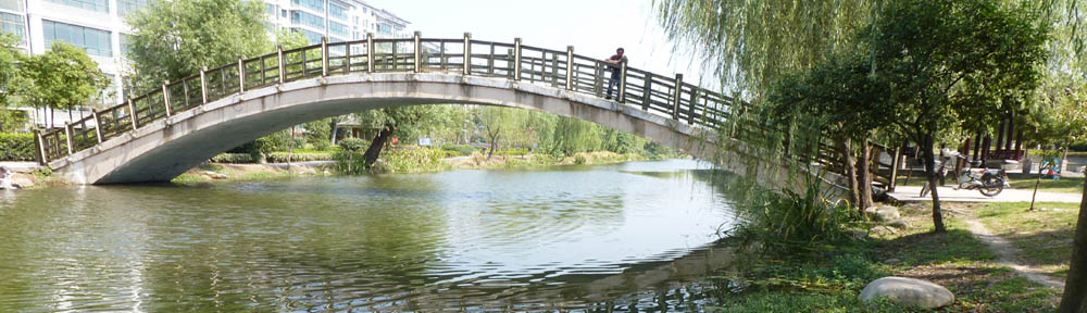
A sense of urgency permeates the air in Lombardy as well as in neighbouring Piedmont, Emilia Romagna and Veneto regions, regarding Italy’s network of navigable canals and rivers. What reality will be revealed to the world of inland waterway specialists and advocates, meeting in Milan on September 1st for the 27th World Canals Conference? It is a reality of water conveyors and waterways, in places going their separate ways, but often combined within the same bed. Waterway cross-roads, intakes, siphons, spillways, aqueducts are the nodes of an intricate network spun across the Lombardy plain, and nothing is simple. Even Italy’s second biggest Alpine lake, Lago Maggiore, is used as a reservoir and drawn down by as much as 1.50m to secure irrigation water supplies during a dry summer.

Article in La Stampa

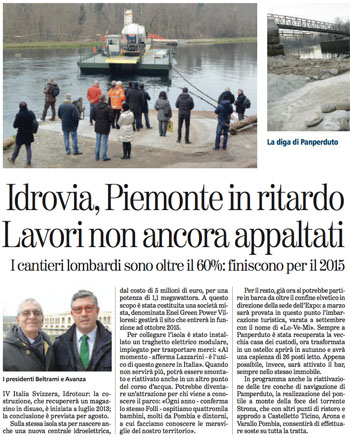
The ambitious project to restore navigation between Lago Maggiore (Locarno) and the river Po is regularly covered by the regional and national Press. This article focuses on work to start soon on a new lock at Porto della Torre, on the Piedmont bank of the Ticino

It is nearly 20 years since IWI’s founders attended a conference in Milan on the ‘civilisation of water and waterways’ and the heritage left by Leonardo da Vinci and other great Italian engineers. At that time a grouping of Rotary clubs in the Adda valley was actively promoting restoration of the locks on the Adda as well as the Naviglio di Paderno (followed by the Martesana towards Milan). The campaign sadly lost momentum after the president Mario Roveda died of a heart attack in 1997, but IWI, represented in Italy by industrial archeology expert Edo Bricchetti, has constantly been supporting the regional initiatives in favour of a navigable system serving ‘slow’ tourism and appreciation of the extraordinary heritage and environment of the canal corridors.

Navigli Lombardi was founded to drive these efforts, but does not manage the canals themselves; that is the prerogative of the Consorzio Villoresi, which has the concession from the Region to manage the water resource and supply the many needs of agriculture, industry and the population. This means that the ‘water conveyor’ function has priority here, in the same way as it has priority on another famous southern European canal, the Canal de Castilla in Spain.

Despite this priority, politicians in Milan and across the plain, including the neighbouring regions, are massively in favour of restoring and adapting the 1000-year legacy of canals and controlled rivers, to make navigation once again a regular form of mobility in both urban and rural areas.

Turbigo spillway

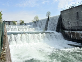
This spillway in Turbigo is only one part of a complex junction between the ‘industrial canal’ and the Naviglio Grande

Achieving this goal means compromises and concessions. As climate change increases the pressure on water resources, it is likely to become increasingly difficult to obtain management of water channels that is compatible with navigability, even by professional helmsmen. Another difficulty faced by all players in Lombardy is a certain degree of confusion in the minds of Milanese citizens, possibly even some planners and architects, between water conveyors and waterways. This is only the briefest of introductions to a fascinating story that will be told here in the coming days and weeks… background notes for the discussions during the World Canals Conference and the pre- and post-conference tours. (to be continued)
David Edwards-May

Boats and sewerage: game over?

The subject is not totally taboo, but in 40 years of activity on the inland waterways, a ‘world of its own’, I have found that people prefer to avoid it. ‘The less said the better’, seems to be the motto ! Confronted with two conflicting ‘politically correct’ opinions, Euromapping decided to undertake a detailed survey, starting on March 1st 2013, to get a precise overview.
It is hardly a caricature to say that ‘canal folk’ justify their direct discharge into the canal by arguing that the environment easily absorbs the effluent load. On the other side, landlubbers are horrified by the idea that tourists are free to ‘do it’ in the canal and shocked by the fact that this ‘public convenience’ is used free of charge.
Historically involved in development of the waterways in SW France, Euromapping is ideally placed to conduct this investigation and assemble reliable data on the Canal des Deux Mers, despite the reluctance of players to address the subject.
All are aware of what is required by EU and French law. The manufacturers know better than anyone, since they fit their boats with the necessary holding tanks, but marine toilets are still the norm on many boats.
The questions are straightforward :
– How are boats equipped for sewerage ?
– Do trip boats, hotel boats, etc. have separate holding tanks for grey water and black water ?
– What is the storage volume ?
– Are pumps integrated on board ?
– What is the interval between pump-outs ? Where are they done ? and by what methods ?
These are followed by qualitative questions designed to note the sensitivities of users and their willingness to pay sanitation services, for those who today have no alternative but to discharge into the canal.
Canals as ecosystems : a session at the World Canals Conference – to be held in Toulouse on 16-19 September – is devoted to this murky subject. It was time for the consulting firm Euromapping to clarify the stakes, with its partners.

What future for Canal du Midi?

VNF’s summary report on its activities in 2012 devotes one of its 10 chapters to the tree-replanting programme and corporate patronage approach to funding the €200 million restoration of the Canal du Midi’s characteristic landscape.

VNF's new logo

VNF has a logo which keeps the old, enriching it with evocative graphics by Philippe Apeloig

VNF reports (in its New Year press release) that it felled 1668 plane-trees condemned by canker stain in 2012, and replanted 68: the uninformed reader immediately sees a ‘deficit’ of 1600 trees. This sad statistic, however inevitable in view of the experimental nature of the first replanting operations, is like a wake-up call. The tree-felling and replanting debate – and the questions surrounding the should not become an excuse for inaction in other areas.
This is one of many concerns expressed by the Toulouse Waterway Information Network, a grouping of waterway interests in SW France. The network (Réseau Fluvial Toulousain) is challenging local and regional politicians to come up with a robust and workable plan to develop the waterway economy. It is convinced that France in general – and in this case SW France – possesses unique skills, resources and capability to make the canal economy more vibrant, and create more jobs, generate more income.
They say this is what the World Canals Conference* should be all about, and call for a debate to be held in the context of this international conference, a debate which should leave no stone unturned in the search for viable management models and economic development for our canals and rivers.
A properly-planned future for the Canal des Deux Mers should be an issue in the 2014 municipal elections, and the réseau hopes that candidates will state their positions in their manifestos.
* Salons Vanel, Toulouse, 16-19 septembre 2013 – see the WCC web site

Unscrambling Pierre Paul Riquet

Aside

Banner outside the Canal du Midi Museum at Saint-Ferréol, to be visited during the 2013 World Canals Conference in Toulouse

The Google Streetview automatic scrambler of peoples’ faces has indiscriminately defaced the creator of the Canal du Midi on a banner outside the canal museum at Saint-Ferréol. This delightful quirk of automation of image processing suggests a new form of request to be made to our omnipotent and omniscient provider of images of the planet: ‘Dear G, Please unscramble the image of Pierre Paul Riquet. He died in 1680, so you’re safe from any legal action!’


‘Regatta’ promotes Serb canals

Radomir  Ječinac  reports from Belgrade, Serbia, on the ‘regatta’ (flotilla cruise) organised on the canals and waterways of Serbia in June/July 2012.

Remember IWI’s annual World Canals Conference held in Serbia, in the beautiful city of Novi Sad on the Danube, in 2009? The host, Vode Vojvodine (Vojvodina waters) is an all-important institution in our country, which was founded to manage the network of artificial canals in this relatively flat province in northern Serbia. When the Irish boat Aquarelle entered Serbia in July of that year (encouraged by WCC co-host Danube Propeller), and Mike and Rosaleen Miller asked for permission to cruise through the Vojvodina canals, this was en eye-opener for Vode Vojvodine, who were encouraged to give official status to what was previously an informal gathering of domestic boaters each year.

VV Regatta Route 2012

Itinerary for the 11-day cruise, including some of the lesser-used canals

The event has since gone from strength to strength, and I joined this year’s regatta, with a full programme to delight Serb boaters for 11 days (see map, left), from June 24 to July 4. This was the 4th to be organized by VV: 10 stages in 11 days over 300km of canals between Novi Sad and Bezdan. Ah, Bezdan! We heave a sigh at every mention of the name, because the entrance lock here from the Danube is still closed. We still had our moneys’ worth, though, since these 300 km represent half of the Vojvoodina network.

Warned that the number of boats had to be limited, the skippers of some 90 motor cruisers and dayboats of all possible types and sizes, 250 people in all, sent their booking forms as soon as the event was announced! Mothers and fathers of families, to say nothing of the Dog‘, as Jerome K. Jerome remarked. There were couples with children who had barely started walking.

Regatta enters the main canal at Novi Sad

Nearly 90 boats enter the main canal at Novi Sad, approaching the first lock on the cruise

Nearly half the  boats came from afar, boat harbours on the Danube or Tisa, for example: from Belgrade, Zemun, Pancevo, Smederevo, Novi Bečej on the Tisa, not afraid of all the extra kilometres and the strong current of the Danube to reach the starting point at Novi Sad. One sizeable boat came from Vukovar, Croatia, thus giving the event its international character.

The regatta’s Commodore was Mirjana Živković, hydrotechnical engineer at VV, petite, a bundle of energy with bright black eyes, tireless and ubiquitous, participating in the regatta herself with her boat and family, ‘to say nothing of the dog’ in this case also! She had to deal with a complex organization: locks, free passage for participating vessels, technical and first aid teams, municipal receptions for participants, refreshments and local cuisine, al fresco meals along the canals, folklore programs, minimum supplies by itinerant merchants, etc.). For us Serbs, with a litre of diesel costing €1.50, and average monthly wages between 300 and 400 euros, the benefits of organised navigation are obvious.

On pages 35 and 36 of the European Waterways Map and Directory (2008 edition) we read of the attraction of this annual regatta for Serbian boaters. IWI can therefore congratulate itself for having contributed in a way to what is now the biggest navigation event in Serbia.

Backi Monostor floating bridge

Backi Monostor floating bridge on one of the little-used canals on the VV system

VV Regatta mooring

The author beside his boat at a quiet mooring in Bezdan

Lille’s canal revival on hold

What does Lille, the historic capital of Flanders, have in common with Milan and Tokyo? Or even with The Hague, featured in this blog a few days ago?

It is a city that is determined to revive its historic intimacy with water, or what our Lombardy friends elegantly describe as la civiltà delle acque, or civilisation centred on water. This means reversing the trend which started in the years after World War II – covering or infilling small canals, or piping underground small streams – justified at the time by two benefits: public hygiene, and more roads for vehicle traffic.

Porte d'eau, Lille

The Porte d'eau or 'water gate' on the old river Deûle in Lille

In recent years, Lille’s Mayoress Martine Aubry has seen many reports pointing to the role revitalised canals could play in the city’s development, but the current ambitious plans date roughly from the time the Canal de Roubaix restoration was being completed, in 2009. The EU Blue Links project is a separate story, but it is clear that the remarkable success of that restoration and the Blue Days festivities in September 2009 gave new impetus to the plans being designed by the city of Lille and the Metropolitan District Lille-Métropole.

As long ago as 1994, working with Mark Lloyd of EuroWaterways Ltd, I wrote of the benefits of opening up Lille’s old canal arms, and architect Roger Beckett showed in some simple drawings how the canal basin in Lomme could become a vibrant boat harbour and urban centre. Since then, how many boats have given Lille a wide berth, skirting round the Citadelle on the high-capacity waterway, without realising what they were missing, or simply regretting that nothing had been done to welcome them in the city?

Map from Inland Waterways of France (2010) showing the old and modern routes of the river Deûle through the city

Determined to implement the proposals of the successive studies, Mayoress Aubry and her council opted for the most ambitious and costly of the three canal arms, the Vieille Deûle, penetrating into the historic city centre. As shown on the map, this involves a new cut to link with the Deûle, part of a local regeneration project called ‘Cœur de Deûle’, and re-excavation of the cut south from the historic Porte d’eau (now a major cross-roads) towards the church of Notre Dame de la Treille. Three design-and-build consortia were selected from six projects, and invited to prepare detailed designs and costings.

Winning design by the Sogea consortium

The winning design for the Vieille Deûle restoration has this straight length of canal past the former Comtesse hospital

In the meantime, I was in another consultancy group advising Lille on an overall master plan for water in the city. I observed that it was unfortunate to spend €40 million on this branch, however spectacular for the city centre, while not treating the other arms, where it seemed more value could be derived from smaller investments.

In essence, the counter-proposal was to restore the link between the Moyenne Deûle south of the Citadelle and the modern waterway downstream of the Grand Carré Lock, also developing a boat harbour with all services in the canal basin at Lomme. But the issue of priorities was not the only reservation to be expressed. Councillors faced unexpected opposition to the project at public meetings. Local inhabitants were concerned about car parking, the risk of flooding their cellars (unrelated to the project, but it is hard to overcome prejudices and perceptions); there was also scepticism about the usefulness of the canal arm. Finally, Lille politics clouded the issue. Outlying communes in the metropolitan district felt that the investment was going to benefit the central commune of Lille, and should be balanced by other investments to boost waterway tourism throughout the network. This is the purpose of the Plan Bleu for Lille Métropole, in which I have also been involved, with landscape architect Alfred Peter.

To cut a long story short, the Vieille Deûle project through to the Avenue du Peuple Belge has been put on hold, while the overall strategy of the Plan Bleu is defined and eventually approved by elected representatives throughout the metropolitan area, from the Belgian border and the pastoral landscapes of the Lys valley in the north to the former coal mining belt in the south.

Lille and the Deûle/Marque river basin

The projects in the city of Lille (green rectangle) will now be part of a wider overall plan for the waterways throughout the metropolitan area

This means that boaters will also have to wait for a few more years, while these plans mature and are implemented, hopefully with less political wrangling and a clearer understanding of how all these canal projects are in the common interest of the population and tourists throughout the region.

Once this understanding has been reached, and the Plan Bleu approved, the Vieille Deûle project will be back on the agenda, and should hopefully be completed in the medium term. In the meantime, the old route round the Citadelle, via La Barre lock, should be back on the map! This will complement another major tourism and heritage project in the open space between Vauban’s fort and the city centre.

The Hague’s canal ring revived

‘Small is beautiful’ could be a motto for canals, especially in cities. And this simple precept is now being followed in the Netherlands with spectacular results. This was the main lesson learned during the EU Waterways Forward partnership meeting in The Hague on May 30th-June 1st.

During the first day of proceedings, May 31st, delegates discovered the ambitious canal restoration plans of South Holland and the association of local authorities RegioWater. The above extract from their planning map shows the remarkable density of ‘water routes’ which could potentially be opened up to navigation in boats of the appropriate dimensions. The green lines are all routes not normally available to recreational boats, while the crosses mark specific obstacles to be lifted, usually very low fixed bridges. The one furthest to the west, the Moerbrug, is said to be too low even for swans to pass under!

Ooievaart boat trip in The Hague

The Ooievaart boat trip starts from the Hooikade

A vivid demonstration of the issues – and the potential – was provided in the afternoon, as the 25-strong delegation (with members from the UK, Ireland, France, Italy, Poland, Hungary, Latvia, Norway and Serbia, as well as the host country) embarked on two open trip-boats run by the association Ooievaart, to discover the ring of canals (green on the map, beside the name Den Haag).

Despite rain of similar intensity to that experienced by the million visitors at the Thames Pageant for the Queen’s Diamond Jubilee three days later, the 90-minute trip was both entertaining and instructive, as the history of the capital was explained street by street, bridge after bridge. Entertainment came from the numerous covered sections of the canals, where we all had to bend over completely to squeeze under beams, pipes and other protruding parts. It was like being in a surgeon’s probe, exploring the entrails of The Hague.

The Hague canal tunnel

Atmosphere in one of the tunnelled sections of the canal ring

And lo and behold! Structures were already in place to start implementing the RegioWater plan by removing the canal’s cover, to expose it and restore it to its rightful place in the urban environment. As in Lille and in Leipzig, the argument for covering the canals (or infilling them completely) was salubrity, in the absence of proper sewerage systems. With proper sewerage, water quality is now very good.

Covered section in the new centre of The Hague

Entering the covered section in the new centre of The Hague

The idea, as the IWI tour discovered in Leipzig in April 2011, is to use the opportunity of maintenance or replacement works to raise the bridges and increase the available headroom.

This means that navigability in larger craft can only be a long-term objective, but the process is to be hailed, as well as the opportunities for exploring such canals in small craft.

Forty years after I was blocked in a hireboat on the canal route south from Groningen to Coevorden, which had just been closed, the phase of economic development which led to the abandonment of so many small canals has clearly come to an end. ‘Small canals’ are now being revived on a significant scale, in both town and country.

Canals cross EU eastern borders

In just a few years, three bottlenecks on the eastern borders of the European Union will have been removed, thanks in part to the persistent efforts of many organisations working together, campaigning and lobbying for canals, waterways and inland navigation.

First to be completed was the restoration of the Augustowski Canal in Poland and its continuation in Belarus’ through to the Neman river, opened in 2009. The second, long-awaited, development is the construction of a permanent lock in Brest-Litovsk at the western end of the Dnieper-Bug Canal (see map in header).

Mukhovets River in Brest © Google Earth

The lock will replace the weir bypass on the left bank (bottom of this view, © Google Earth) with its two earth dams

This lock should replace in 2012 the temporary earth dam structure which for many years blocked through navigation to Poland’s Bug River. Finally, the canalised river Bega will be opened from the Tisa in Serbia through to Timosoara in Romania; again work is in progress on restoration of the first lock in Romania.

Our exhibition From Limerick to Kiev: Waterways for Tomorrow’s Europe contributed to promotion of these projects by showing in 2003/2004* how an integrated European waterway network is a concern for tourism and long-distance recreational boating, just as it is a concern for industrial and economic development through inland water transport. The exhibition map and panels were also shown at the boat lift at Strépy-Thieu in Belgium in 2004, and at a session of the Working Party on Inland Waterways at the United Nations Economic Commission for Europe in Geneva.

Boatowners have for long been planning long-distance cruises throughout the continent, as shown by this planning map for the cruise of a lifetime from Paris to Moscow, Perm and Arkhangelsk.

A complementary issue is that of regulations for crossing that eastern border (or ‘internal border’ in the case of Serbia-Romania); discussions are in progress and outline agreements have been reached, one having been signed recently in Warsaw by Poland and Belarus’, but in practice there are still substantial administrative hurdles to overcome. Such cruises have now become feasible, at least in terms of reglementation, since the Russian Federation passed a law on May 25th allowing foreign recreational boats to use its inland waterways.

Waterway route to the Urals and the White Sea

The route planned by Richard Parsons with Xanthos

* first in Grenoble, for the 10th anniversary of foundation of Euromapping, then in October 2004 at the European Parliament building in Brussels; the partners for that operation were IWI, the Alliance Internationale de Tourisme, the European Boating Association, DBA The Barge Association and ICOMIA

Canals and waterways worldwide…

… and all who use them!


Welcome to IWI’s blog! The association, founded in 1995*, aims to raise awareness of the value of navigable rivers and canals in many of the densely-populated regions of the planet. Lobbying for governments’ attention and spending on waterways for moving freight and all their other functions is a constant challenge. The other transport modes carry more weight in corporate terms, while tourism and recreational uses are considered by many decision-makers as ‘secondary’ functions, to be planned and managed at the regional or local level. So not only are we in a minority as voters in elections, we are also promoting widely differing types of waterway and economic uses, with separate political levels of responsiblity and decision-making!

In this situation, where inland waterways are ‘off the radar’ of most politicians, and often only partially on the radar of the others, communication is critical to achieving our objectives. We hope that this blog will contribute to strengthening the links among like-minded people and organisations. It’s also about a certain philosophy, a way of appreciating unique cultural landscapes and environments that we have on our doorsteps, at the same time supporting the ongoing use of waterways for transporting goods, as lifelines for industry. This means new, larger canals and locks or lifts, and building missing links in Europe, Asia, North and South America, Africa, where justified in economic and environmental terms.

As with any lobbying organisation, a lot of work is conducted behind the scenes. All who wish to join in are more than welcome! Details on our Membership page. These public pages will cover a wide range of topics, many derived from the web sites we have been managing for the last 15 years.

We look forward to working with you in furthering the cause of sensible spending to build and maintain inland waterways for their many economic, environmental and social benefits.

* from the International Committee of the Inland Waterways Association, UK, founded by the late Ronald W. Oakley