Vive VNF under its new statute as a public administration! Following the successful public consultation process, the State body is expected to start works on enlarging the Creil-Compiègne section of the river Oise to European Class Vb capacity. The works are needed to harmonise navigable dimensions throughout the Seine-Scheldt waterway. The public consultation was completed successfully in 2012, and aspects of the project were then debated at three “post-consultation” workshops in December. The first covered all hydraulic aspects, the flood risk and highest navigable water level, the second was devoted to the various uses of the inland waterway, while the third discussed all environmental aspects.
Tag Archives: waterway bottlenecks
End of road for Seine-Nord?
The Seine-Nord canal project is now very close to being abandoned by the French Government, along with the Lyon-Turin rail link and base tunnel and about 15 other sections of the high-speed rail network, promoted in 2010 under the ‘Grenelle’ package of measures for the environment (reported by Les Echos)
An ‘excuse’ for abandoning the canal project, which is the subject of transnational agreements with Belgium and the Netherlands, is the increase in estimated cost of the 106km long canal, with 7 locks, from €4.5 billion to €5 or 6 billion. The statement by Secretary of State for the Budget Jérôme Cahuzac also calls into question the economic viability of the project.
The article in Les Echos underlines the difference in treatment between railway and waterway projects mentioned in the July 6 post on this subject.
a) The high-speed railway lines where works have already started are saved from the chop; the preparatory works already carried out on Seine-Nord appear to count less; they include the lowering of a section of the A29 motorway to allow for the future aqueduct.
b) The economic return on the canal is doubted, but no mention is made of the rate of return on the railway projects; assumptions are made, fuelled by environmentalist policies, on the network benefits of adding new sections to the rail network, while the network effect of linking the Seine basin to the Rhine is ignored or at least underestimated in a purely financial analysis. (It takes time to set up new logistics practices and transport chains.)
The competitive dialogue between VNF, project authority, and the two candidates, Bouygues and Vinci, is to be completed by October, but it seems that the construction giants have themselves been playing into the hands of the new Government, by preparing for abandonment of the project. They have been ‘going through the motions’, while possibly even agreeing that the project was a non-starter and increasing the cost estimates. The limits of the PPP exercise have been starkly revealed.
Evidence of this possible ‘death foretold’ is the attitude of the two companies, whose leaders hardly reacted to the news, as if they had themselves been promoting what Les Echos describes as an inevitable ‘return to reality’.
It remains to see what pressure the European Commission and the Belgian and Dutch partners in the Seine-Scheldt project can bring to bear on the French Government, to restart the project on a sounder basis. The EU’s funding share for the Lyon-Turin base tunnel would alone pay for the new canal! Even at €6 billion, the cost of the canal is only a fraction of the €260 billion cost of all the the planned high-speed rail lines.
Canals cross EU eastern borders
In just a few years, three bottlenecks on the eastern borders of the European Union will have been removed, thanks in part to the persistent efforts of many organisations working together, campaigning and lobbying for canals, waterways and inland navigation.
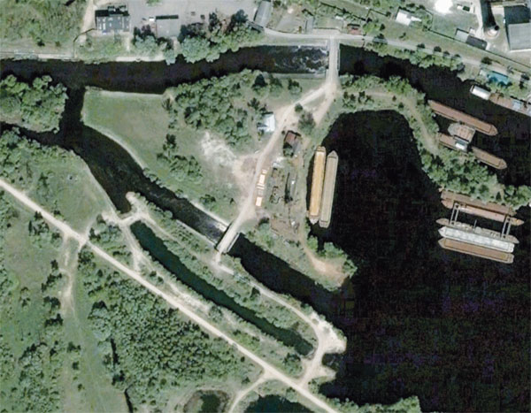
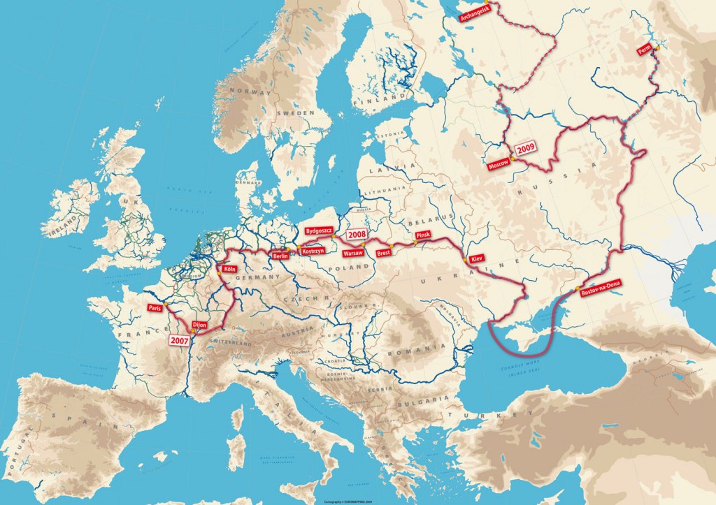
First to be completed was the restoration of the Augustowski Canal in Poland and its continuation in Belarus’ through to the Neman river, opened in 2009. The second, long-awaited, development is the construction of a permanent lock in Brest-Litovsk at the western end of the Dnieper-Bug Canal (see map in header).

The lock will replace the weir bypass on the left bank (bottom of this view, © Google Earth) with its two earth dams
This lock should replace in 2012 the temporary earth dam structure which for many years blocked through navigation to Poland’s Bug River. Finally, the canalised river Bega will be opened from the Tisa in Serbia through to Timosoara in Romania; again work is in progress on restoration of the first lock in Romania.
Our exhibition From Limerick to Kiev: Waterways for Tomorrow’s Europe contributed to promotion of these projects by showing in 2003/2004* how an integrated European waterway network is a concern for tourism and long-distance recreational boating, just as it is a concern for industrial and economic development through inland water transport. The exhibition map and panels were also shown at the boat lift at Strépy-Thieu in Belgium in 2004, and at a session of the Working Party on Inland Waterways at the United Nations Economic Commission for Europe in Geneva.
Boatowners have for long been planning long-distance cruises throughout the continent, as shown by this planning map for the cruise of a lifetime from Paris to Moscow, Perm and Arkhangelsk.
A complementary issue is that of regulations for crossing that eastern border (or ‘internal border’ in the case of Serbia-Romania); discussions are in progress and outline agreements have been reached, one having been signed recently in Warsaw by Poland and Belarus’, but in practice there are still substantial administrative hurdles to overcome. Such cruises have now become feasible, at least in terms of reglementation, since the Russian Federation passed a law on May 25th allowing foreign recreational boats to use its inland waterways.
* first in Grenoble, for the 10th anniversary of foundation of Euromapping, then in October 2004 at the European Parliament building in Brussels; the partners for that operation were IWI, the Alliance Internationale de Tourisme, the European Boating Association, DBA The Barge Association and ICOMIA
Filling gaps on the river Lot
Impressive progress is being made on the most ambitious waterway restoration project in France, the 270km long river Lot. Although massive hurdles remain to be overcome at the large hydroelectric dams – Fumel, Luzech and Cajarc – the project conceived in 1973 by Christian Bernad, president of the Association Aménagement Vallée du Lot, is moving slowly but surely towards eventual completion.
The above map shows the downstream section of the river, from the confluence with the Garonne through to the département Lot and its chief town Cahors. This highlights the relatively short missing links. Within the département Lot et Garonne two locks need to be built, one at Saint-Vite and the 8m deep lock beside the dam at Fumel. Above Fumel is the boundary with the département Lot, which was initially content with its 64km navigable section opened in 1991. Under pressure from local authorities, however, this département committed to opening further lengths of the river, hence the 12km extension upstream (not on this map) and especially the series of 9 locks over a length of nearly 40km between Fumel and Albas.
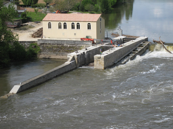
One of our members has just sent this view of works in progress at one of these locks, Floiras, number 18 on the above map*. As at many locations on the river Lot, the head is exploited by a small hydropower plant, so that the lock is located at some distance from the river bank.
When this lock is opened later in 2012, the missing link to the middle section of the Lot at Luzech will be only 7km long, including the large-scale works at Luzech itself (probably requiring a new tunnel) and the 3.70m deep lock at Albas.
For details of French waterways and projects throughout the network, see my guide Inland Waterways of France, published by Imray.
Let us know what you think about the River Lot Restoration project!
* The idea of numbering the locks, from 1 (Nicole) to 57 (Marcenac) was put forward in a planning study completed by the author in 1992, to give a sense of unity among the projects implemented piecemeal along the different sections of the river. This idea has not been taken up to date, one reason being that the projects for the missing links remain to be confirmed in terms of technical, financial and economic feasibility.
The featured image (click on title of post if necessary, to see it) has been amended to take into account the elimination of Escambous lock; the hypothetical total is therefore 57 and not 58 locks as originally posted. Click on the image below for an overview of the upstream section.


