Move for restoration of Locarno-Milan waterway

Claudio Repossi of Navigli Lombardi reports on a series of events to raise awareness of the historic, cultural and recreational values of the Locarno (Switzerland) to Milan waterway via the river Ticino.

As part of the joint Italian-Swiss project Intrecci sull’acqua – or Dialogue on the Water – a series of initiatives have been launched, including guided tours of the area and pleasure boating on Lago Maggiore (Verbano), along what is known as the ancient ‘Marble Route’.
(supplying marble for the construction of Milan’s cathedral).

Events planned for the weekends of July, August and September were organised thanks to an agreement between the municipalities involved, the Lombardy Region, the Province of Novara and Navigli Lombardi, the last of which has been active for years with its passenger boat service on the Ticino running between Sesto Calende and the Miorina Barrage (and former lock).

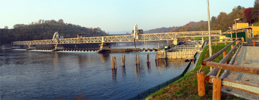
Miorina Lock and Dam

Miorina Lock and Dam on the Ticino River in Lombardy, on the 'Marble Route' (photo © Vito Antongiovanni)

The project includes navigation on the Ticino and on the Lake, partially covering the route taken of old by the barges that carried the precious construction material along the lake-river-canal waterway to Milan.

Today the former waterway is no longer navigable throughout, but great efforts are being made, at a time of crisis in public finances, to reopen it. Miorina lock on the Ticino has recently been restored to working order, and the Panperduto dam, machine hall and adjacent lock are also being rehabilitated. Begun in 2011, the works are financed by Lombardy Region, Consorzio Villoresi, Navigli Lombardi and the electricity utility ENEL, and are to be completed in 2013. Piedmont Region for its part is gathering the funds necessary for the restoration of the Porto della Torre barrage.

Once the works to restore the hydraulic structures on the Ticino are finished, it will be possible to navigate from Lago Maggiore to the start of the Industrial Canal, with four locks to restore as the last obstacle before the final link-up with the Naviglio Grande and Milan.  The Naviglio Grande is already navigable from Turbigo to Cuggiono, albeit with some size limits.

With Expo 2015 in view, an accord for an integrated plan for maintenance of the infrastructure of Milan’s canals and for the valorization of the Navigli and Lombardy waterways as an asset to tourism, the environment and culture, was promoted in May this year by the Lombardy Region, Consorzio Villoresi and Navigli Lombardi. Also involved are the Park management bodies for the Adda Nord Park, the Ticino Park, and the South Milan Agricultural Park. The programme, requiring an investment of around €20million for works to be carried out by June 2015, proposes substantial repairs to the banks of the Naviglio Grande and Naviglio Martesana. It has among its primary objectives the promotion of a Leonardo da Vinci cultural tourism trail along the Lombardy waterways where he experimented successfully with some of the most brilliant hydraulic inventions: the lock flight, the Da Vinci lock and its characteristic stepped upper sill. It also aims to promote the ‘Feed the Planet’ programme, principal theme of the 2015 Milan Expo.

Kindly translated by Maggie Armstrong, ‘Spigolizzi’

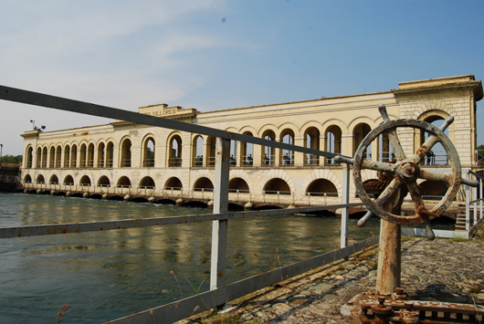
Panperduto dam

Panperduto dam and Villoresi hydropower plant on the Ticino, with one of the lock-gate winding capstans in the foreground (photo © Zilvana)

Lille’s canal revival on hold

What does Lille, the historic capital of Flanders, have in common with Milan and Tokyo? Or even with The Hague, featured in this blog a few days ago?

It is a city that is determined to revive its historic intimacy with water, or what our Lombardy friends elegantly describe as la civiltà delle acque, or civilisation centred on water. This means reversing the trend which started in the years after World War II – covering or infilling small canals, or piping underground small streams – justified at the time by two benefits: public hygiene, and more roads for vehicle traffic.

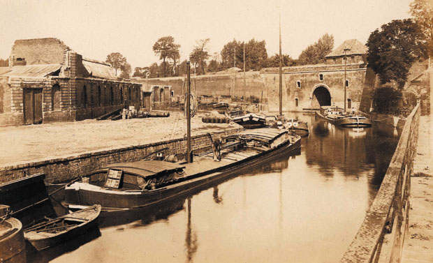
Porte d'eau, Lille

The Porte d'eau or 'water gate' on the old river Deûle in Lille

In recent years, Lille’s Mayoress Martine Aubry has seen many reports pointing to the role revitalised canals could play in the city’s development, but the current ambitious plans date roughly from the time the Canal de Roubaix restoration was being completed, in 2009. The EU Blue Links project is a separate story, but it is clear that the remarkable success of that restoration and the Blue Days festivities in September 2009 gave new impetus to the plans being designed by the city of Lille and the Metropolitan District Lille-Métropole.

As long ago as 1994, working with Mark Lloyd of EuroWaterways Ltd, I wrote of the benefits of opening up Lille’s old canal arms, and architect Roger Beckett showed in some simple drawings how the canal basin in Lomme could become a vibrant boat harbour and urban centre. Since then, how many boats have given Lille a wide berth, skirting round the Citadelle on the high-capacity waterway, without realising what they were missing, or simply regretting that nothing had been done to welcome them in the city?

Map from Inland Waterways of France (2010) showing the old and modern routes of the river Deûle through the city

Determined to implement the proposals of the successive studies, Mayoress Aubry and her council opted for the most ambitious and costly of the three canal arms, the Vieille Deûle, penetrating into the historic city centre. As shown on the map, this involves a new cut to link with the Deûle, part of a local regeneration project called ‘Cœur de Deûle’, and re-excavation of the cut south from the historic Porte d’eau (now a major cross-roads) towards the church of Notre Dame de la Treille. Three design-and-build consortia were selected from six projects, and invited to prepare detailed designs and costings.

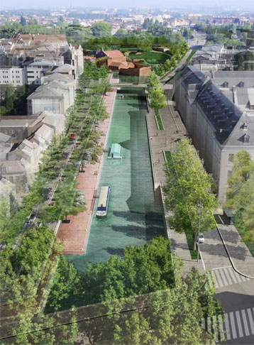
Winning design by the Sogea consortium

The winning design for the Vieille Deûle restoration has this straight length of canal past the former Comtesse hospital

In the meantime, I was in another consultancy group advising Lille on an overall master plan for water in the city. I observed that it was unfortunate to spend €40 million on this branch, however spectacular for the city centre, while not treating the other arms, where it seemed more value could be derived from smaller investments.

In essence, the counter-proposal was to restore the link between the Moyenne Deûle south of the Citadelle and the modern waterway downstream of the Grand Carré Lock, also developing a boat harbour with all services in the canal basin at Lomme. But the issue of priorities was not the only reservation to be expressed. Councillors faced unexpected opposition to the project at public meetings. Local inhabitants were concerned about car parking, the risk of flooding their cellars (unrelated to the project, but it is hard to overcome prejudices and perceptions); there was also scepticism about the usefulness of the canal arm. Finally, Lille politics clouded the issue. Outlying communes in the metropolitan district felt that the investment was going to benefit the central commune of Lille, and should be balanced by other investments to boost waterway tourism throughout the network. This is the purpose of the Plan Bleu for Lille Métropole, in which I have also been involved, with landscape architect Alfred Peter.

To cut a long story short, the Vieille Deûle project through to the Avenue du Peuple Belge has been put on hold, while the overall strategy of the Plan Bleu is defined and eventually approved by elected representatives throughout the metropolitan area, from the Belgian border and the pastoral landscapes of the Lys valley in the north to the former coal mining belt in the south.

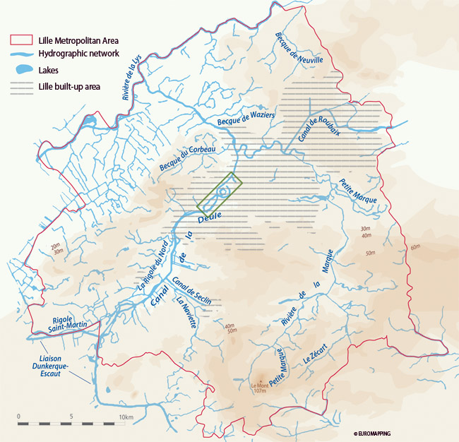
Lille and the Deûle/Marque river basin

The projects in the city of Lille (green rectangle) will now be part of a wider overall plan for the waterways throughout the metropolitan area

This means that boaters will also have to wait for a few more years, while these plans mature and are implemented, hopefully with less political wrangling and a clearer understanding of how all these canal projects are in the common interest of the population and tourists throughout the region.

Once this understanding has been reached, and the Plan Bleu approved, the Vieille Deûle project will be back on the agenda, and should hopefully be completed in the medium term. In the meantime, the old route round the Citadelle, via La Barre lock, should be back on the map! This will complement another major tourism and heritage project in the open space between Vauban’s fort and the city centre.

The Hague’s canal ring revived

‘Small is beautiful’ could be a motto for canals, especially in cities. And this simple precept is now being followed in the Netherlands with spectacular results. This was the main lesson learned during the EU Waterways Forward partnership meeting in The Hague on May 30th-June 1st.

During the first day of proceedings, May 31st, delegates discovered the ambitious canal restoration plans of South Holland and the association of local authorities RegioWater. The above extract from their planning map shows the remarkable density of ‘water routes’ which could potentially be opened up to navigation in boats of the appropriate dimensions. The green lines are all routes not normally available to recreational boats, while the crosses mark specific obstacles to be lifted, usually very low fixed bridges. The one furthest to the west, the Moerbrug, is said to be too low even for swans to pass under!

Ooievaart boat trip in The Hague

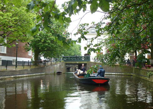
The Ooievaart boat trip starts from the Hooikade

A vivid demonstration of the issues – and the potential – was provided in the afternoon, as the 25-strong delegation (with members from the UK, Ireland, France, Italy, Poland, Hungary, Latvia, Norway and Serbia, as well as the host country) embarked on two open trip-boats run by the association Ooievaart, to discover the ring of canals (green on the map, beside the name Den Haag).

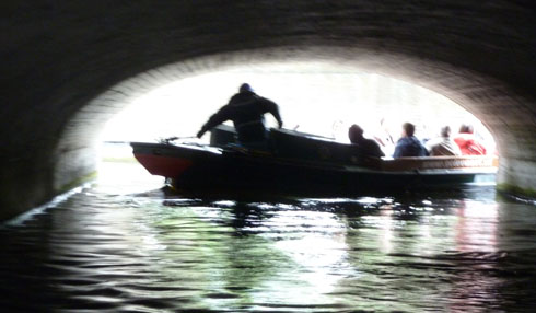
Despite rain of similar intensity to that experienced by the million visitors at the Thames Pageant for the Queen’s Diamond Jubilee three days later, the 90-minute trip was both entertaining and instructive, as the history of the capital was explained street by street, bridge after bridge. Entertainment came from the numerous covered sections of the canals, where we all had to bend over completely to squeeze under beams, pipes and other protruding parts. It was like being in a surgeon’s probe, exploring the entrails of The Hague.

The Hague canal tunnel

Atmosphere in one of the tunnelled sections of the canal ring

And lo and behold! Structures were already in place to start implementing the RegioWater plan by removing the canal’s cover, to expose it and restore it to its rightful place in the urban environment. As in Lille and in Leipzig, the argument for covering the canals (or infilling them completely) was salubrity, in the absence of proper sewerage systems. With proper sewerage, water quality is now very good.

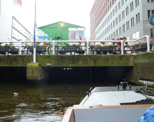
Covered section in the new centre of The Hague

Entering the covered section in the new centre of The Hague

The idea, as the IWI tour discovered in Leipzig in April 2011, is to use the opportunity of maintenance or replacement works to raise the bridges and increase the available headroom.

This means that navigability in larger craft can only be a long-term objective, but the process is to be hailed, as well as the opportunities for exploring such canals in small craft.

Forty years after I was blocked in a hireboat on the canal route south from Groningen to Coevorden, which had just been closed, the phase of economic development which led to the abandonment of so many small canals has clearly come to an end. ‘Small canals’ are now being revived on a significant scale, in both town and country.

Lombardy’s key role in world canal history

Edo Bricchetti, a member of IWI’s Council and The International Council for Conservation of Industrial Heritage (TICCIH), has been tirelessly defending the priceless heritage of Lombardy’s historic canals, the navigli, working closely with the responsible authorities for more than 20 years. During this time, although it does not directly manage the canals, Lombardy Region has set up an agency, SCARL Navigli Lombardi, whose task is to coordinate restoration works, develop tourism and promote the heritage of the canals themselves and their corridors; these canals are the ideal vector to visit gems of architecture, enjoy cultural landscapes and see countless vestiges of the industry that for centuries used the abundant waters crossing the plain.
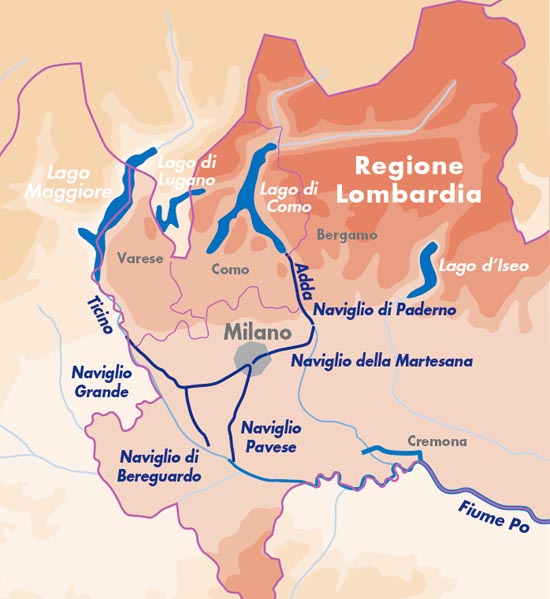
The Lombardy canal system

The five navigli between the partially canalised rivers Ticino and Adda

Lombardy at the time of Leonardo da Vinci
When Leonardo da Vinci arrived in Milan in 1482, he discovered works of hydraulic engineering that were already unrivalled in Italy or even throughout Europe. The Viarenna lock, within the city limits, had already been in operation for 40 years, while to the north-east the city was served by the Naviglio della Martesana.
During his 25 years in Milan, Leonardo was to make a significant contribution to improvement of the waterway system which was the most extensive and strategic in Europe at that time.
Between the Ticino and the Po the Padua plain is divided horizontally into distinct sections, between the arid and infertile strip of land to the north and the well-watered lower plain to the south, better suited to agriculture. Springs, irrigation feeders, channels and offtakes conveyed water for irrigation, where formerly spring water and the left-bank tributaries of the Po flowed into stagnant marshes. The canals enabled cultivation of vast areas of arid land to the north of wide tracts of low vegetation and dense heathland. On this network, in the towns, in the villages and countryside, grain mills were established, oil presses, basins for husking rice, paper and felt mills, presses for working metals, tanneries for leather. In short, all economic activity revolved around the waterways, which acquired strategic importance in the regulation of flows for hydraulic energy and for transport.
Lombardy civilisation was founded on this combined use – for industry and agriculture, leading to the development of considerable areas of land, where traditional trades and crafts coexisted with new forms of agriculture, new manufacturing industries, trades and communications.

Brief history of the canal system
Situated roughly half way between the Ticino and the Adda, Milan has always seen these two rivers as potential outlets to the sea through the Po. After abandoning the idea of a direct connection to the broad river through the Lambro, the city concentrated on a system of canals, which were built over a period of seven centuries.
They are divided into two subsystems. The Naviglio Grande, the Naviglio di Bereguardo and the Naviglio di Pavia belong to the Ticino; the Naviglio Martesana and Naviglio di Paderno are connected to and supplied from the Adda. These were linked by the fossa interna or canal ring in the centre of Milan, not unlike the grachten which characterised Dutch cities. Commercial activity was concentrated in the large basins at Porta Ticinese and San Marco.
However, Milan’s dream of becoming a seaport remained unfulfilled for many years, mainly for political reasons, but also on account of objective technical difficulties of navigation (climatic events, irregular river flow regime, problems of water table rise, and competition with nearby cities for control of the waterways). All these obstacles were overcome by the practical approach of the Milanese who already in Roman times, from the second century AD, adapted the smaller rivers Seveso, Nirone and Vettabbia for small-scale navigation.
Ravenna, capital of the Empire of Bysance and Pavia, capital of the eastern Roman empire, served as centres of exchange of produce between the Orient (precious metals, woven cloth, spices and miscellaneous goods) and the West (weapons, timber, construction materials, foodstuffs).
Around the year 1000, Milan, Lodi and Pavia were in bitter competition for access to the river outlets, especially Lodi, protected by the Emperor Federico Barbarossa, and Milan, elected a free City. In particular Barbarossa, who founded the new city of Lodi on 3 December 1158, granted it the status of exclusive port of the Adda. Milan fought bitterly to defend its only access to the Adda through the Lambro, navigable at that time. Inevitably, only three years after the battle of Legnano and the historic victory of Lombardy Communes over the Emperor (1179), the Milanese started work (in the village of Panperduto) on a canal for trade on the left bank of the Ticino. The canal was to transport goods originating from Verbano and nearby Switzerland, thus releasing the city from blockades and imperial control. They were assisted by a flood which, by inundating land near the canal, suggested the extension of the section already built between Abbiategrasso and Landriano (Ticinello, 1157). The limit of navigation was extended in 1187 to Trezzano, in 1211 to St Eustorgio bridge in Milan, and in 1253 to Gaggiano (Naviglio di Gaggiano). The third section, completed in 1257, finally completed the Verbano-Ticino-Milan system.
In 1272 the canal, called the Naviglio Grande, was already in regular use by barges, transporting wood, hay, cheese, cattle, marble and granite to the city, while “exports” upstream included salt, iron, grain and various manufactured goods.
To the south, however, Milan could rely only on the Navigliaccio, completed by order of Gian Galeazzo di Visconti in 1359, for irrigation of Castello di Pavia (and later extended for 8 km to the Certosa di Pavia), and on the Naviglio di Bereguardo, between Abbiategrasso and Bereguardo.
Meanwhile, they applied themselves to connection of the Naviglietto (1156) to the Lombardy waterway network through the Conca di Viarenna (1440) near the lake of Sant’Eustorgio. This connection suggested the future development of a circular canal connecting all the navigli, with the Porta Ticinese canal basin at its centre.
The Incoronata (‘coronation’) lock at San Marco, near Borgo Nuovo at Porta Orientale (built under decrees for reform of navigation by Ludovic the Moor dated 13 October 1496 and 15 April 1497), completed the connection of waters of the Ticino to those of the Adda.
The latter was reached via the Naviglio Piccolo del Martesana, thus named after the county it crossed. Construction of this waterway, of great strategic importance for the city’s economic development, was suggested by the Milanese demand for goods originating in the Valtellina and the Valsassina valleys, especially after the conquests of Lodi and Pavia, from 1335 and 1339. Goods would be carried down the Lario and Adda rivers.
Thus the excavation of the Naviglio del Martesana was completed in only six years, between 1457 and 1463, from Concesa to Cassina de’ Pom. The gradient of the waterway made it possible to provide irrigation offtakes throughout its length, and hydraulic energy for manufacturing works, as well as navigation. The goods transported were principally (heading downstream) coarse and dressed quarry stone, lime, bricks, metals, sand and gravel, weapons and tools in wrought iron, foodstuffs and agricultural produce, wood and coal; boats would return upstream from the city towards the lake with some manufactured goods, but the main cargo was salt. The economic importance of this waterway soon led to the construction of a genuine, dedicated inland port in the San Marco basin in Milan.
However, the waterway suffered from the interruption caused by the Paderno rapids which prevented navigation in the section between Paderno and Cornate d’Adda. Shattered on these rapids were not only a number of intrepid boatmen, but the Milanese dream of uninterrupted navigation from lake Como to the city. Goods thus had to be transhipped and transported overland from Brivio to Trezzo, that is from the confluence of the Lario to the only waterway effectively navigable to the east of Milan, the Naviglio del Martesana.
The French king François I thus decided in 1516 to give the city of Milan 10 000 ducats per year, in support of construction of a new navigable canal, to serve his own political ambitions. Various projects were drawn up, which revived the old idea of a direct link from the lake at Lecco to Milan. A public commission, made up of the engineers Bartolomeo Della Valle and Benedetto de Missaglia, surveyed various solutions which suggested using successively water diverted from the Lambro, then from the Molgora, the Seveso, the Lura and the Olona, and finally, Lake Como. The latter option was chosen, with a choice of two routes: the first was for a major new canal, leaving the river at Brivio and running across the plain via Vimercate and Monza directly to Milan; the second involved using the Naviglio del Martesana and the river Adda from Trezzo to Brivio.
The latter project was judged feasible within space of two years and with the sum of approximately 50 000 Ecus. The Milan Senate decreed on 26 September 1518 to choose this second option, which again was debated between two engineering approaches. Should navigation be developed within the natural river bed, removing all obstacles (using locks in the bed of the river itself)? or should the river bed be avoided in certain sections, by building by-pass canals on the Milanese side of the valley? The second approach, proposed by engineer Benedetto de Missaglia, was chosen. This involved excavation of a canal on the Milanese side of the valley from the locality called Tre Corni to the sacred site of La Rocchetta. Placed in charge of the works was the architect and painter Giuseppe Meda, author (in 1574) of the project for a magnificent structure of masonry, portals and lock-gates in timber, bridges and various mechanisms, capable of overcoming the difference in level of the rapids with a single pound lock featuring separate upstream and downstream gate structures, called castelli d’acque (or ‘water towers’). The downstream structure was originally to be built to a height of 17.82m, while the upstream structure was 5.94 m high. However, various difficulties, compounded by the plague of 1567 and above all by bureaucratic delays, led to abandonment of the initiative.
Construction was in fact approved by the King of Spain only in 1590. The works started between 1590 and 1593 finished in the aftermath of disputes and trials which dragged on between 1596 and 1597. Meda even carried weapons on him as he went about his business, to defend himself.
Meda died in August 1599, and with him all ambitions for completion of the enterprise. The water introduced in the first section in 1603 was drained away completely in 1617, on account of the impossibility of keeping the pound watertight; the inlet was blocked off, the site installations were dismantled and the materials sold off. Under Spanish domination (1525-1748), Milan went through a period of total inertia, again complicated by the bitter opposition of Como and Bergamo to all plans for navigable canals to Milan, which they considered as a serious threat to their own traffics.
Had it not been for the determination of some of Meda’s followers, and for the clear and precise designs of the Austrian administrators, supported by the Italian engineers, the works would never have been completed. It was under the first period of Austrian domination (1748-1796) that the ambitious project for implementation of the Naviglio di Paderno was revived. The studies were revised by count Firmian, representative of the Austrian government in Lombardy, by the adviser Pecis and by mathematicians Antonio Lecchi, Francesco Maria De Regis and Paolo Frisi. Count Firmian, responsible for approval of the works, finally advised minister Kaunitz to accept the bid by the contractor Nosetti (13 July 1773). The project provided for reuse of Meda’s lock foundations, but with the height of the downstream lock reduced to about a third of that in Meda’s original plan.
Nosetti doubted the feasibility of a lock as deep as that proposed by Meda, and envisaged breaking up the difference in level into six pounds instead of two, with the canal’s intake and outlet established respectively at Sasso di San Michele and Valle della Rocchetta.
On 11 October 1777 the canal was opened to navigation amid intense public and official festivities, in the presence of count Firmian, whose inaugural boat proceeded down the canal from Brivo to Vaprio, with the Archduke of Austria also on board. However, a structural failure at one of the locks delayed final opening of the canal until 6th October 1779.

Lombardy, a land of engineers never fully appreciated, and of works left incomplete

© Prof. Edoardo Bricchetti, 1998, edited by David Edwards-May, 2012
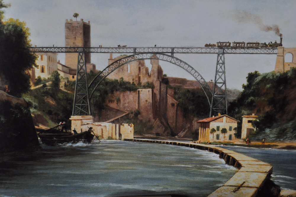
Martesana entrance and Trezzo viaduct in 1891

Iron bridge at Trezzo sull'Adda, opened for the Monza-Bergamo railway in 1890; the painting by Carlo Jotti dates from the following year, and shows the entrance to the Naviglio della Martesana in the foreground
 

Canals cross EU eastern borders

In just a few years, three bottlenecks on the eastern borders of the European Union will have been removed, thanks in part to the persistent efforts of many organisations working together, campaigning and lobbying for canals, waterways and inland navigation.

First to be completed was the restoration of the Augustowski Canal in Poland and its continuation in Belarus’ through to the Neman river, opened in 2009. The second, long-awaited, development is the construction of a permanent lock in Brest-Litovsk at the western end of the Dnieper-Bug Canal (see map in header).

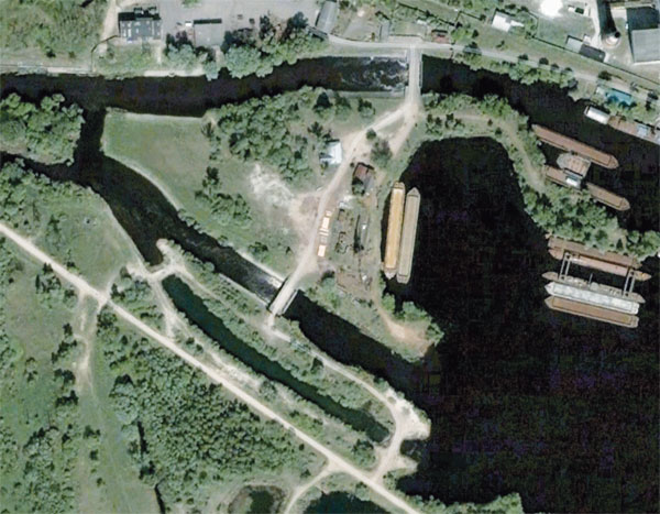
Mukhovets River in Brest © Google Earth

The lock will replace the weir bypass on the left bank (bottom of this view, © Google Earth) with its two earth dams

This lock should replace in 2012 the temporary earth dam structure which for many years blocked through navigation to Poland’s Bug River. Finally, the canalised river Bega will be opened from the Tisa in Serbia through to Timosoara in Romania; again work is in progress on restoration of the first lock in Romania.

Our exhibition From Limerick to Kiev: Waterways for Tomorrow’s Europe contributed to promotion of these projects by showing in 2003/2004* how an integrated European waterway network is a concern for tourism and long-distance recreational boating, just as it is a concern for industrial and economic development through inland water transport. The exhibition map and panels were also shown at the boat lift at Strépy-Thieu in Belgium in 2004, and at a session of the Working Party on Inland Waterways at the United Nations Economic Commission for Europe in Geneva.

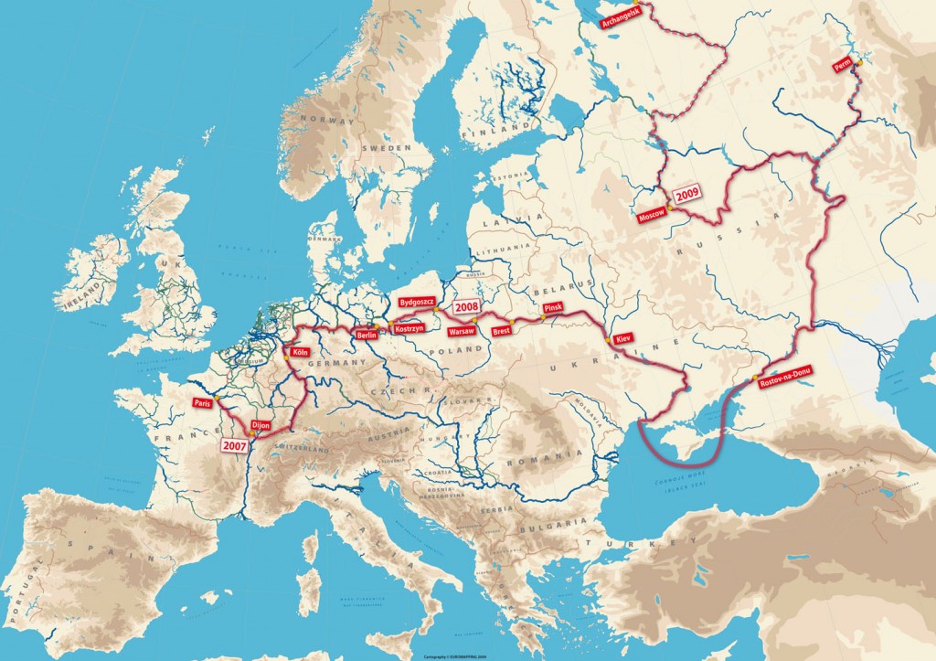
Boatowners have for long been planning long-distance cruises throughout the continent, as shown by this planning map for the cruise of a lifetime from Paris to Moscow, Perm and Arkhangelsk.

A complementary issue is that of regulations for crossing that eastern border (or ‘internal border’ in the case of Serbia-Romania); discussions are in progress and outline agreements have been reached, one having been signed recently in Warsaw by Poland and Belarus’, but in practice there are still substantial administrative hurdles to overcome. Such cruises have now become feasible, at least in terms of reglementation, since the Russian Federation passed a law on May 25th allowing foreign recreational boats to use its inland waterways.

Waterway route to the Urals and the White Sea

The route planned by Richard Parsons with Xanthos

* first in Grenoble, for the 10th anniversary of foundation of Euromapping, then in October 2004 at the European Parliament building in Brussels; the partners for that operation were IWI, the Alliance Internationale de Tourisme, the European Boating Association, DBA The Barge Association and ICOMIA

Chanaz harbour an ill-conceived development?

It is sad how ideas conceived with the best of intentions by local politicians sometimes go hopelessly wrong because their implementation is dictated by trends and political expediency.
Visiting Chanaz on May 6, I discovered this impressive addition to what is already a superb site, and one of my top 10 waterside villages in France. This is at the western end of the Canal de Savières which links the upper river Rhône to Lake Bourget.
You see this ‘lakeside village’ and think ‘the architects had fun there’. You see hundreds of people enjoying the site on a glorious May day. Then your attention is drawn to the fine pontoons complete with water and electricity points. And you wonder why none of the chalets has been rented, and why there are no boats in the harbour?

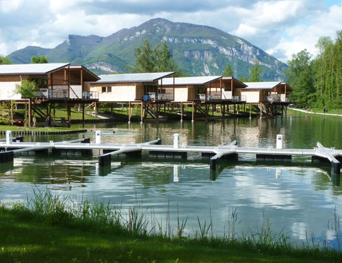
New Chanaz harbour

New harbour and pontoons, but no boats

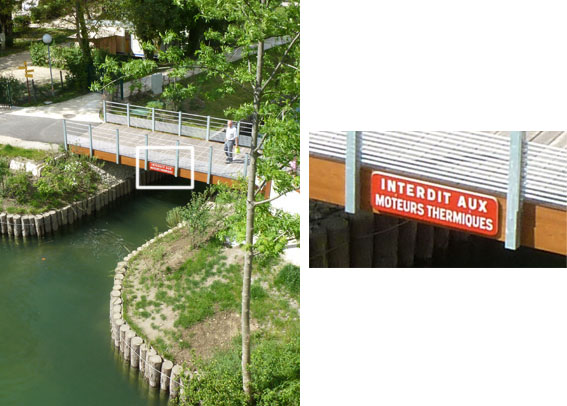
Then comes the explanation… and the disappointment, at least on the second observation. Access to this idyllic harbour is open to electrically-powered boats only (as well as unpowered craft), as shown by the sign on the swing-bridge over the harbour entrance.

The only electric boats present in the region are open boats for hire by the hour, and would not be clients for such an installation. So it seems that the mayor and his council have either been misled by the designers of the project, or have given in to pressure from environmentalists or government departments.

By excluding nearly all powered craft, the harbour and its pontoons are rendered practically useless, and that part of the total investment of EUR 1.8 million will be sadly wasted, while the ‘regular’ moorings along the backwater of the Rhône at Chanaz are fully occupied with many boats on the waiting list.  European regulations on boat engine emissions and noise (through the technical requirements for inland waterway craft) are increasingly stringent, so excluding boats from this harbour is a misguided choice.

Erie Canal in downtown Rochester NY

Former IWI president Tom Grasso has been campaigning for eight years to bring back to life the enlarged (1842) Erie Canal in downtown Rochester, NY. The World Canals Conference was held here for the second time in September 2010. ‘The event took us a dramatic and profound step forward in terms of raising awareness of the Erie Canal’s potential today, its robustly storied past and the iconic 1842 aqueduct in downtown, for both the general public and the international assembly of delegates.’

‘The evening reception in the aqueduct, the “Dinner in the Ditch”, made a lasting impact. It still echoes in the community. Thanks to our sponsors, partners, and hard work of the planning committee the WCC was a world-class act of the highest caliber in program, content, and social events. Today we should build on the conference’s success and keep the momentum.

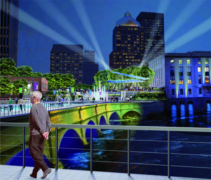
Artist's impression of the Erie Canal aqueduct over the Genesee River after restoration

‘We must not let the lessons learned and the ideas discussed wither and die. Now is the time to consider our City’s future while building upon the past. We need to use this opportunity to leverage other urban waterway development initiatives from around the world, not just our old Erie Canal and aqueduct.

‘Consider our history: America’s first inland boom in the early years was fueled by the construction of the Erie Canal. If not for the canal, Rochester would not be what it is today. The mid-1800s expansion of the second Erie Canal, the Enlarged Erie, through the City created the 1842 aqueduct (Broad Street Bridge) that still stands today, the only intact old Erie Canal urban aqueduct on the system.

‘By the early 20th century Rochester had outgrown the canal and when the fourth Erie Canal was completed in 1918 it took an end run around the city and the old canal bed was converted into a subway by roofing over the canal trench with Broad Street. The subway operated from c.1925 to 1956 when it too faded into oblivion.

‘The projected rewatering is all about turning historical features into engines of economic revitalization. Cities around the world have restored or are planning to restore their historic waterways: in Korea, Japan, China, France, Belgium, the Netherlands, England, Denmark,… North America is no exception as waterway projects, bristling with successful economic revitalization, have been completed in a number of cities: in Montreal, Oklahoma City, Providence, and San Antonio. The fact that water restoration projects have been successful in so many different countries proves that it is a cross-cultural phenomenon and a primal basic instinct uniting all of humanity: attraction to water.

‘Rochester decision-makers are unable to commit to major public investments in the current climate. Yet developers know that waterfront property is more valuable; there are no substitutes for waterways in urban settings as engines of economic revitalization and regeneration. Imagine what it would be like to live, walk or eat dinner right next to the water on Broad Street, as you can do in Pittsford or Fairport. A waterway with boats and a wide promenade is a magnet for housing, shops and restaurants, bringing new jobs.

‘Canal Development is a proven money-maker; the British have made significant investments in canals to revitalize urban areas. In his book Britain’s Restored Canals, Roger Squires points to restoration as a catalyst for economic growth : over $12 billion equivalent has been derived from canal redevelopment.

‘To keep this project alive, we must keep up the pressure, but it is a constant struggle. An overwhelming majority of the delegates at the 2010 conference urged us to continue bringing the old Erie Canal to life again through downtown Rochester. We have received messages of support from the Chairman of British Waterways, and Jim Stirling, engineer, who led the BW team that built that the Falkirk Wheel in Scotland and restored the two canals that the Wheel united. He stated in the September 24th 2010 issue of the Democrat & Chronicle that a canal brought back to life is a like a magnet that draws people and businesses such as pubs, marinas, as well as light commercial developments and residences.

‘This economic model can work in a city like Rochester! Magical canal and waterway restorations have converted a no-go industrial canal wasteland in Oklahoma City, virtually nothing but a streetscape, into something wonderful and really special. We in Rochester also have the opportunity to accomplish something truly exceptional but with the added value of brand-name recognition. Restoration of the iconic old Erie Canal will have a robust economic impact on the downtown Historic Old Erie Canal District corridor and the city as a whole. Canal history has handed us a gift : we have, cradled in our hands, an enormous opportunity to achieve something truly special. Who among us can envisage consciously taking something so special and, in direct contrast to Oklahoma City, transforming it into absolutely nothing?

‘Now we have set up the World Canals Conference 2020 Planning Committee. We know that we will be in competition with other host countries and cities. But our ambition is to host the event in the year 2020 to inaugurate either the construction of or the grand opening of a fully re-watered old Erie Canal into downtown Rochester. The Committee plans to consign to history a century of wanton neglect, and to celebrate in 2020 the complete revival of Erie’s water downtown, as an engine of economic revitalization.’

(Interview with Tom Grasso in May 2011)